I am sharing some highlights from my recent road trip the week after Christmas leading to the New Year of 2021. Note that I did the drive straight from Seattle to Death Valley and drove home from San Jose, skipping the entire state of Oregon. Normally for two people, I wouldn’t recommend everyone to take the exact route since there was a lot of driving involved. Winter road conditions are also very unexpected, and if you’re not familiar with snow driving, I do recommend waiting until summer and fall to do this trip.
In 2019, I took my cousins on a California loop road trip starting from San Francisco, so you can read that blog post here if you’ve never been to California and just want to fly there.
MORE ROAD TRIP IDEAS AND STOPS YOU CAN TAKE IN OREGON:
12 Best Oregon Coast Stops for Your Road Trip
The Best Portland Travel Guide – Where to Eat, Visit, and Shop
Trip Summary:
First night, we drove through the night and made it to a hotel in Reno, Nevada. Initially, we wanted to do Alabama Hills and Death Valley first but ended up doing Joshua Tree instead because of the rain. After that, we spent a few days at a relative’s house on the east side of Los Angeles. North California and Oregon Coast were initially in our plan, but we did California Coast and visited some relatives in San Jose before driving straight home to Seattle.
CAR RENTAL:
My partner and I rented an SUV with high clearance for off-road and winter driving. The first car that we got was filled with cigarette smells, so we switched out to a new car in Portland. We did anticipate at least some nights sleeping in the car, so we packed along with pillows, blankets, and our camping kit.
LODGING:
We ended up sleeping in the car twice, and the first night in a city near Death Valley. The second night, we stayed on a dirt road a mile away from the paved road in Stovepipe Wells. It’s the closest to Mesquite Flat Sand Dunes, so we did successfully wake up early and completed the hike to the tallest dunes for sunrise.
Due to COVID and the stay-at-home order at the time, all National Park campgrounds and lodging in California were closed (as of winter 2020 – 2021). However, Death Valley National Park itself was still open, except the road to Scotty’s Castle north of Death Valley.
Since the park is so big, disperse camping is encouraged as long as you follow the park’s rules. Campgrounds are closed to discourage group gatherings of 8 or more people. Learn about Death Valley camping here!
For the rest of the trip, we booked hotels along the way and stayed at a relative on the east side of California.
15 Best Stops for Your Seattle to California Road Trip (All in California)
- Mobius Arch Loop Trail, Alabama Hills
- Zabriskie Point Lookout, Death Valley National Park
- Golden Canyon and Gower Gulch Loop via Zabriskie Point, Death Valley National Park
- Artist’s Palette, Death Valley National Park
- Badwater Basin, Death Valley National Park
- Mesquite Flat Sand Dunes, Death Valley National Park
- Fortynine Palms Oasis Trail, Joshua Tree National Park
- Cholla Cactus Garden, Joshua Tree National Park
- Skull Rock, Joshua Tree National Park
- Christmas Nights, 123 Farm, Cherry Valley (SoCal)
- El Matador Beach, Malibu
- Butterfly Beach, Santa Barbara
- Leadbetter Beach, Santa Barbara
- 17-mile Drive, Monterey Peninsula
- Davenport Pier, Davenport
- Apple Park, Cupertino
- Stanford University Campus
1. Hike Mobius Arch Loop Trail, Alabama Hills, CA
According to Alltrails, Mobius Arch Loop Trail is a 0.6 mile EASY heavily trafficked loop located in Lone Pine, California. It’s an awesome short trail with an incredible view of Mt. Whitney and many cool rock formations along the hike. Don’t miss the Mobius Arch.
Expect to spend an hour or more here and start on the right side of the trail since the left side is steeper and might be covered with more snow. It’s a loop, so either starting point works. Do layer and wear sturdy shoes if you’re here in the winter due to snow. I think there is a California pass for state parks, but I don’t see any enforcers around at the time. There are also lots of camper vans, so I’d definitely come back here to camp in the future.
OUTFIT: Sweater: thrifted | denim jacket: vintage LEVI’S, boots: DANNER (mine is the suede version, color is Sand, gift from DICK’S purchase here), leggings: LULU LEMON | beanie: NORSE PROJECTS


2. Zabriskie Point Lookout, Death Valley, CA
I got here right when the sun was rising, and the colors were magical. I had been here once in August two years ago when it was screeching hot. In the winter, the weather is much milder, but keep in mind that it can get quite cold at night.
Please note that this is a lookout, so from the parking lot, you can just walk straight to the viewing platform. It is paved, and it is that amazing. Definitely plan for sunrise or sunset here if you can.

3. Hike Golden Canyon and Gower Gulch Loop via Zabriskie Point, Death Valley, CA
Access to this trail is on the right side of the Zabriskie Point Lookout’s parking lot. I didn’t know this at first, but we managed to get back out following this trail sign. It is quite flat, and you can get down to the valley floor as well as hike up to the hills following trail signs. The colors and rock formations here will blow your mind. I highly recommend this trail!
For more information about this trail, please read reviews here.
OUTFIT: sweater: thrifted | leggings: LULU LEMON | beanie: NORSE PROJECTS |boots: DANNER


4. Drive Artist’s Palette Drive, Death Valley, CA
The Artist’s Palette drive takes you through canyons and past mountains, and many are covered in colors depending on the lighting or time of the day that you go. Think ice cream flavors like chocolate, mint, strawberry, and more.
Artist Drive is 9 miles, one way, and it should take you about 45 minutes. There are 3 parking spots for you to stop and take a hike inside the canyons. Do not miss the Artist Palette at the second pullout/stop in the drive. From there, take left after you’ve finished the drive and head to Badwater Basin.


5. Hike in Badwater Basin, Death Valley, CA
Badwater Basin is the lowest point in North America at 282 ft (86 m) below sea level. From the parking lot, you’d need to hike in at least 20 minutes (1.5-2 mile (2.4-3.2 km) roundtrip) before getting to the main area where there is a sea of geometric salt polygons.
It’s a flat and easy hike, so I wouldn’t even call it’s a hike. Be sure to look up on the cliffs of the Black Mountains in the east and find the ‘Sea Level‘ sign.
OUTFIT: bra: GIRLFRIEND | leggings: LULULEMON | hat: LULULEMON


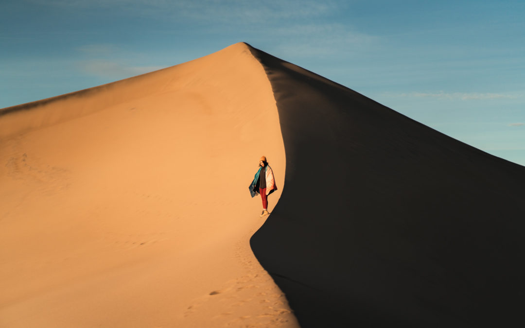
6. Hike Mesquite Flat Sand Dunes, Death Valley, CA
There are no formal or marked trail signs here. From the parking lot, just head straight in to find your favorite spot on the dunes. My tip is to just walk further in to find the tall dunes with no footprints. Pack along with some snacks, water, and layer if you hike the dunes in the winter. Don’t forget sunscreen, too!
I was here for sunset the first night, but we did not get to hike to the dunes we were hoping to get to since the winter sunset was way too fast. We found a dirt road right off Stovepipe Wells and car camped at one of the pullouts a mile away from the paved road for the night. It cooked ramen in the car and got cleaned up with water and wet wipes we packed along. Sunrise was at 7 am the next day, so we started hiking at around 6 am. Luckily, we managed to find some perfectly sharp and un-touched dunes on the right side of the area.
What I wore: I had my Gorumpl blanket, some layers, and a bar for breakfast. The sand is actually very densely packed, so I was happy that I wore my Danner shoes instead of my Luna sandals. My Luna sandals are perfect for water and lose sand hiking, FYI. The temperature dropped to the low 40s at around 4 am in the winter, and that felt even colder in the middle of the desert. Also, don’t forget a beanie to keep your ears warm!
OUTFIT: blanket: GORUMPL | beanie: UNIQLO | jacket: PATAGONIA | leggings: ORGANIC BASICS (10% discount code ANTRIEUOBC2 ends February 2021)


7. Fortynine Palms Oasis Trail, Joshua Tree National Park, CA
Fortynine Palms Oasis Trail is a 3.1 mile heavily trafficked out and back trail located in Twentynine Palms, California. It is inside of Joshua Tree National Park, so make sure you have your National Park pass displayed in the car. There are some uphill and downhill hiking both way-in and way-out, and it is rated as moderate. In the winter, I’d recommend hiking boots and some layers since some parts of the hike get very windy. Expect to spend about 2 hours hiking and relaxing at the oasis.
We drove a lot the night before and get to a hotel in Twentynine Palms, California near midnight of the second day of our trip. The next day, we were able to finish the Fortynine Palms Oasis Trail right around noon, visited the Cholla Cactus Garden in the afternoon, and explored the Skull Rock area a little bit before the light was gone.
OUTFIT: leggings: GIRLFRIEND | shirt: LULU LEMON | cardigan: thrifted | beanie: NORSE PROJECTS


8. Cholla Cactus Garden, Joshua Tree National Park, CA
I’d recommend stopping by Joshua Tree National Park visitor center to pick up a park map and freshen up. There are 4 visitor centers here, and the Oasis Visitor Center is my favorite since it seems to be the biggest and clean.
From Oasis Visitor Center, it is about 27 minutes to get to Cholla Cactus Garden. My first-hand experience with these chollas was in Saguaro National Park when I did the American Southwest road trip back in October 2020. Please stay on the trail and avoid touching the chollas because they stick to your clothes and skin. Removing them is a very painful process! It is not a trail but more like a stroll on a flat path! Definitely, a fun stop if you’re in Joshua Tree.
OUTFIT: beanie: ACNE STUDIOS | everything else is already mentioned in outfits above.


9. Skull Rock Area, Joshua Tree National Park, CA
Skull Rock is located right off the main road, hence, it is very crowded. The rock itself looks cool in person, but it doesn’t wow me. And I only took photos of it on my phone. I ended up walking around the area and got to witness the most incredible sunset on the other side of the road. Pro-tip is just to walk further in and wear some layers since it gets cold at night in the winter.
If you’ve never been to Joshua Tree before, I’d recommend Arch Rock over Skull Rock. Both areas are similar but different, but I think the arch is more iconic. Regardless, these areas are just so picturesque and fun to explore, so make sure you plan your trip accordingly. Camping would be so much fun, too, and I’d go back to Joshua Tree in a heartbeat!
OUTFIT: bra: ORGANIC BASICS (10% discount code ANTRIEUOBC2 ends February 2021) | leggings: GIRLFRIEND | flannel: MADEWELL | sunglasses: RAY-BAN | beanie: NORSE PROJECTS | boots: DANNER


10. Christmas Nights at 123 Farm, Cherry Valley (SoCal), CA
I got recommended this place by a friend, so we decided to drive an hour here on New Year’s Eve. Parking was $10, and admission is free. It is $5 for walk-in guests. 123 Farm’s Christmas Nights starts on the 6th of November, 2020, and ends on January 10, 2021. The last admission ends at 9 pm, and the place is closed at 10 pm.
It is a nice activity to do with your partner, friends, and family during the holiday season. I’d highly recommend it for next year if you’re in the SoCal area. They serve food and hot drinks, and there are good spots for pictures, too!
OUTFIT: sweater vest: thrifted | trousers: PLEATS PLEASE ISSEY MIYAKI | coat: UNIQLO X JIL SANDER +J | sheer bodysuit: ARITZIA | shoes: DR. MARTENS


11. El Matador State Beach, Malibu, CA
El Matador State Beach has a paid lot and not too far away from the famous swimmable Zuma Beach in Malibu, California. You can download the app and enter the lot number, and I’ve paid $3 for an hour here.
We had lunch there, and birdwatching was so much fun. Tide was quite high, so we didn’t get to walk further north to explore the caves and arches.
OUTFIT: bra: GIRLFRIEND | bike shorts: GIRLFRIEND | flannel: MADEWELL | sunglasses: RAY-BAN


12. Butterfly Beach, Santa Barbara, CA
Butterfly Beach is definitely a popular beach in Santa Barbara. The sandy part here is thin, so all I see are people walking their dogs and watching the sunset near the water’s edge. You can rent a bike here, but there is no public bathroom so plan accordingly. My favorite is to drive around the neighborhood and drool over so many fancy resorts and estates here!
OUTFIT: tank and skirt: thrifted | sunglasses: CELINE | bag: TELFAR | jewelry: MEJURI 10% edit.mejuri.com/antrieu


13. Leadbetter Beach, Santa Barbara, CA
Leadbetter Beach is my most favorite beach stop out of all of the beach stops in this trip. The parking lot is a paid lot, and there are picnic tables and grills. Locals enjoy surfing and sailing. Pro-tip is to head east from the parking lot and take your time to enjoy the view. I love watching the sunset at the beach!
OUTFIT: tube top: thrifted | denim jacket: vintage LEVI’S | trousers: VELVET HEART *gift | sandals: LUNA SANDALS *gift | beanie: NORSE PROJECTS | jewelry: MEJURI


14. 17-mile Drive, Monterey Peninsula in Pebble Beach, CA
If you have a few hours or a day, I highly recommend the 17-mile Drive, Monterey Peninsula in Pebble Beach, California. There are 3 entrances to start the 17-mile drive in Pebble Beach, California. Admission costs $10.50 per vehicle, and they will give you a map and pass for your car. The gate fee is reimbursed with a purchase of $35 or more at all Pebble Beach Resorts restaurants, excluding Pebble Beach Market. It is complimentary for overnight guests of The Lodge at Pebble Beach, The Inn at Spanish Bay, and Casa Palmero.
I stayed at the Mariposa Inn and Suites in Monterey, minutes away from the south entrance of the 17-mile drive. For the best experience, I’d highly recommend you start the drive at the north entrance since all of the stops are numbered from the lowest there. Plus most pull-outs for cars are on the right side of the roads only. Make sure you really take your time to make it worth the money and stop at recommended places numbered in the map. My most favorites are stops towards the end of the drive. Do not miss Seal Rock, Bird Rock, Fanshell Beach, Ghost Trees, and most importantly the famous Lone Cypress.
The private goft-courses are nice to look at, but I don’t personally care so much. I think nature should be enjoyed by all, and the fact that most of this drive is us looking from the outside in these rich people’s properties, it might not be worth it for some. Regardless, I’m still glad I’ve got to do this drive since it’s been in my bucket list for a while now.
OUTFIT: sweater: EVERLANE | trousers: MM6 MAISON MARGIELA *thrifted | beanie: UNIQLO | cardigan: thrifted


15. Davenport Pier, Davenport, CA
We decided to stop by Davenport Pier to find that IG–famous swing on the beach. Unfortunately, it’s all ruined by the waves, and access to the beach is impossible at high tides. Shark Fin Cove is literally a mile/1 minute drive down the street, so do stop at both places if you’re in Davenport, California.
Davenport Pier is made famous by photographers, especially those who find their way down to the beach. However, photos can also be taken from the bluff top which is much safer, and you can totally just watch the thing from here. The waves are so big that you feel like you’re so close to the ocean. I highly recommend it!


16. Apple Park, Cupertino, CA
Apple Park is the corporate headquarters of Apple Inc., located at One Apple Park Way in Cupertino, California. Usually, you’d be able to shop at the Apple Store inside Apple Park. I’ve been there once before and love the architecture here. Even the bathrooms are also so nice! I love the futuristic vibe here with lots of glass, symmetry, and rows of what look like olive trees.
I love visiting Apple Park and get all kinds of desserts at the Main Street Cupertino shopping area.
At Main Street Cupertino, there are SomiSomi (my favorite when it comes to taiyaki filled and soft serve ice cream), Meet Fresh (we have Meet Fresh in Seattle, too, and I love their grass jelly desserts.), Philz Coffee (a must if you’re in the Bay area! Their coffee is great, and I cannot wait to try their beans that I’ve picked up there soon.), Boiling Point, 85-degree Bakery, Target. Note that this area is very busy, so parking might be difficult. Avoid large group gathering during COVID because this place seems to be the place for that!


17. Stanford University, Stanford, CA
We made a quick stop to tour the campus architecture of Stanford University when in the San Jose area. It’s famous for the historic sandstone quadrangle with Romanesque features and the Memorial Church. I love the courtyard, archways, oak trees, and symmetry.
OUTFIT: top: THE LINE BY K | jeans: LEVI’S Made & Crafted | bag: TELFAR | shoes: DR. MARTENS


SHOP THIS POST:

Lastly, I’ve shared notable food stops in California on my Instagram, HERE. Feel free to leave me a comment or DM if you need specific recommendations. I hope you’ve found this blog post helpful. If you want more road trip ideas, check out my previous road trip itineraries below: