To really explore the American Southwest, you’d need weeks or months to see it all. Personally, I think breaking it into a 4-day weekend to a week-long and stretch it over a few trips is the best way to travel these days. There’s no need to quit your job or have huge savings, doing a road trip like this, I think, is the best way to explore America.
In this post, I will walk you through top things to do and places to go see along with a few hikes and easy nature spots in Arizona and New Mexico.
- Stay, Eat, & Shop in Phoenix, AZ
- Stay, Eat, Shop in Tucson, AZ
- Cactus Forest Drive, Saguaro National Park East, AZ
- Mica View Trail, Saguaro National Park East, AZ
- Bajada Loop Drive, Saguaro National Park West, AZ
- Gates Pass, Tucson Mountain Park, Tucson, AZ
- Mission San Xavier Del Bac, Tucson, AZ
- Stay, Eat, & Shop in Sedona, AZ
- Devil’s Bridge, Sedona, AZ
- Chapel of the Holy Cross, Sedona, AZ
- Cathedral Rock, Sedona, AZ
- Tlaquepaque Arts & Crafts Village, Sedona, AZ
- Biosphere 2, Oracle, AZ
- Drive through Petrified Forest National Park, AZ
- Desert Inn & Painted Desert Trail, Petrified Forest National Park, AZ
- Blue Mesa Trail, Petrified Forest National Park, AZ
- Crystal Forest, Petrified Forest National Park, AZ
- Interdune Boardwalk, Playa Trail, Dune Life Nature Trail, White Sands National Park, NM
- White Sands Backcountry Trail, White Sands National Park, NM
- Alkali Flat Trail, White Sands National Park, NM
- Ship Rock, New Mexico
ARIZONA
1. Stay, Eat, & Shop in Phoenix, AZ
We started and ended our trip at Phoenix. Phoenix has the Phoenix Sky Harbor Airport and is closed to well-known cities such as Scottsdale, Chandler, Tempe, and Mesa.
WHERE TO EAT IN PHOENIX:
-
Cocina Madrigal Tacos + Tequila (4044 S 16th St, Phoenix, AZ 85040): This is by far the best Mexican restaurant that I’ve ever been to. I loved everything I ordered and still dream about the thin handmade tortillas. Chef and owner Leo introduced himself to us, and that explained a lot as to why the restaurant has gotten so many 5-star reviews on Yelp.
-
The Parlor Pizzeria (1916 E Camelback Rd, Phoenix, AZ 85016): Great atmosphere, service, and
-
Taco Boy’s (620 E Roosevelt St, Phoenix, AZ 85004): Taco Boy’s is only 7 minutes away from the airport. I love that they cook their meat in an Open fire of Mesquite Charcoal wood, full of tasty smoky flavor!
-
Jin Shabu (2055 N Dobson Rd #C5, Chandler, AZ 85224): All-you-can-eat shabu-shabu with great beef and seafood options and a veggie buffet. Hot pot or shabu-shabu makes a great place for groups and to satisfy any soup cravings. Note that this is in Chandler, 30-minute drive Southeast of Phoenix.
PLANT SHOPS IN PHOENIX:
I’m sharing my list of plant shops that I’ve visited during the trip since some of you have asked about it. I did purchase some cacti and brought them on the plane home. In case you’re curious, I got two big cacti on the plane without any questions asked. Plant shops in Arizona are not normal plant shops, and they’re huge nurseries, growers, and suppliers.
-
Plant Stand Arizona (6420 S 28th St, Phoenix, AZ 85042): 10-acres, 4 greenhouses, and a huge pottery selection
-
Whitfill Nursery (2647 E Southern Ave, Phoenix, AZ 85040): located next to plant Stand Arizona that it specializes in desert landscaping. They have some houseplants in-stock, so make sure to ask the staff.
-
Pueblo (1002 E Pierce St, Phoenix, AZ 85006): Pueblo is a boutique plant shop that is just a few blocks from downtown Phoenix. Great houseplants and cute gift selection.
-
Dig It Garden (3015 N 16th St, Phoenix, AZ 85016): They have a great variety of unique cacti and indoor plants. I bought 2 cacti here!
-
Phoenix Desert Garden (3525 E Southern Ave, Phoenix, AZ 85040): Huge cactus selection at a great price.
WHERE TO STAY IN PHOENIX:
Sheraton Mesa Hotel at Wrigleyville West (860 N Riverview, Mesa, AZ 85201-3605)
2. Stay, Eat, Shop in Tucson, AZ
WHERE TO EAT IN TUCSON:
-
Serial Grillers (5975 E Speedway Blvd, Tucson, AZ 85712): They’re known for cheesteaks, pizza, burgers and calzones. I got a salad and a Vanilla agave drink, super refreshing!
-
Ken’s Hardwood Barbecue (5250 E 22nd St, Tucson, AZ 85711): They were out of ribs since we stopped by right before they were closed for the day. Regardless, their briskets and BBQ sauces are some of of the best I have ever had.
-
Ni Hao Tea (4726 E Broadway Blvd, Tucson, AZ 85711): A solid boba tea shop, highly recommend if you’re in Tucson.
PLANT SHOPS IN TUCSON:
-
Green Things (3384 E River Rd, Tucson, AZ 85718): Green Things is the best nursery out of all of the nurseries I’ve been to in Arizona.
-
Mesquite Valley Growers Nursery (8005 E Speedway Blvd, Tucson, AZ 85715): There are a lot to see here. I loved walking around and discovered lots of roses, citrus plants as well as cacti.
-
B & B Cactus Farm (11550 E Speedway Blvd, Tucson, AZ 85748): 2-acre farm specializing in cacti and succulents. Kind people working here, and I did buy a big cactus at a really good price!
WHERE TO STAY IN TUCSON:
Sheraton Tucson Hotel & Suites (5151 E Grant Rd, Tucson, AZ, 85712)
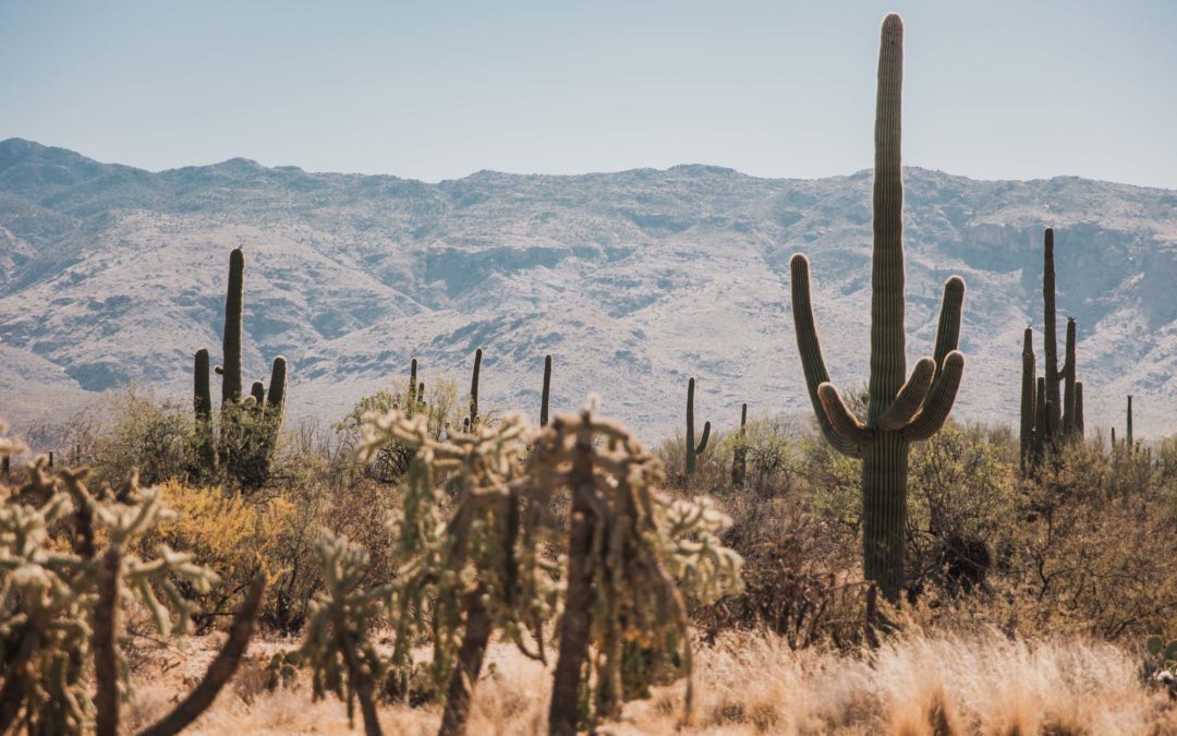
Saguaro National Park, Tucson, AZ
Saguaro National Park has 2 districts: Saguaro East and Saguaro West that are geographically separated by the city of Tucson. West District has a higher concentration of saguaro cacti, but I think exploring the East District is equally as fun.
-
West District, Saguaro West, or Tucson Mountain District
-
East District, Saguaro East, or Rincon Mountain District
Fun facts about saguaro cactus: Saguaro is pronounced as Sa – WAH – ro, and its scientific name is Carnegiea gigantea. It’s native to the Sonoran Desert and has a long lifespan, up to 250 years. Inside Saguaro National Park, there is no specific saguaro recognized as the tallest, and in fact, lots of young and small ones. It’s a slow-growing cactus, and saguaro’s white waxy flowering season is late April through June.
TIPS TO EXPLORE SAGUARO NATIONAL PARK SAFELY & RESPONSIBLY:
-
Avoid wearing sandals and watch out for the jumping chollas.
-
Make sure to bring plenty of water, food, have sun protection: hat, sunscreen, sunglasses, and wear proper clothing before venturing out or hiking.
-
Cellphone reception and wifi are limited in both districts, so download the map area in advance
Saguaro National Park East aka The Rincon Mountain District (RMD)
Start your adventure at the Rincon Mountain Entrance Station/visitor center and follow the park map (available at the visitor center). Saguaro National Park East has an older saguaro compared to the West side.
3. Do the Cactus Forest Drive, Saguaro National Park East, AZ
-
8 miles, winding road but paved, a combination of one- and two-way road with scenic vistas, pullouts, and trailheads
-
Stop at Javelina Rock if you want to view the sunset inside the park. It’s an easy stop and wander spot, located at the end of the Cactus Forest Drive.
-
Scenic drive map, here
4. Hike Mica View Trail, Saguaro National Park East, AZ
-
Mica View Loop Trail is a 3.7 mile heavily trafficked loop trail located in Saguaro National Park, East District.
-
It was a pretty hot sunny day, so we only did half of the trail and turned back. There is a good amount of cacti with cool interesting shapes and sizes. It’s a fun trail!


The Red Hills Visitor Center is a pretty nice place to start your Saguaro West adventure. Saguaro National Park West has a higher density of saguaro than the East side with a younger saguaro forest.
5. Do the Bajada Loop Drive, Saguaro National Park West, AZ
-
5 miles, gravel road with scenic vistas, pullouts, and trailheads.
-
Don’t miss the petroglyphs (prehistoric rock art) at the Signal Hill Picnic Area in the West district.
-
Scenic drive map, here
6. Catch the sunset on Gates Pass, Tucson Mountain Park, Tucson, AZ
-
Gates Pass is not a part or inside of Saguaro National Park, but it’s near Saguaro West district. Gate Pass is a mountain pass. The road through the pass is a scenic drive with overlooks that are best known for sunset watching.
-
You can simply plug in Gates Pass on Google Map. Direction: Get on E Speedway Blvd, and follow West until it turns into W Gates Pass road. After about 3 miles, there is a parking lot as well as multiple viewing platforms with trails where you can walk up a small hill or hike down to the valley.


7. Visit Mission San Xavier Del Bac, Tucson, AZ
-
Mission San Xavier Del Bac is a historic Spanish Catholic mission church located 10 miles south of downtown Tucson, Arizona. Address: 1950 W San Xavier Rd, Tucson, AZ 85746.
-
There is no admission charge to visit Mission San Xavier. Church is open for visitors as well as the gift shop.
-
Learn about the history and architecture, here.


8. Stay, Eat, & Shop in Sedona, AZ
WHERE TO EAT IN SEDONA:
If you’re planning a Sedona trip in advance and have a restaurant in mind, I recommend reserving a table at least a day in advance. Most places get a lot of hype on Google and reviews on Yelp due to such a large amount of tourists. If you want to come in anyway, you might get lucky or certainly feel free to put your name down for the table. There are tons of shops within walking distance, so have a plan.
- Hideaway House (pizza, Italian): I decided to put my name down for a table and waited nearly an hour and a half for a table that night here. It’s t night, the restaurant looks normal, nothing really special except the sunflower logos seen everywhere. I had their famous Brick chicken, Peach pizza, French onion soup, and a margarita, and I enjoyed everything. Our waiter is also super nice!
- Layla’s Bakery-Cafe (3190 W State Rte 89A #200, Sedona, AZ 86336): We went in for a quick coffee and bakery right after the Devil’s Bridge Trail because I was so hungry. I don’t recommend getting coffee here, and the bakery is just ok. It’s nice at least because of the location.
- Wildflower (101 N, AZ-89A, Sedona, AZ 86336): Ok, this place is surprisingly amazing and fresh! The place gives me the Panera Bread vibe, but it is way better! I love that they take orders at the counter or online, and food comes out pretty fast. The place is big enough, so people can get in line indoors. Think desert Sedona heat, and waiting outside is something you don’t want to do, especially when you’re hungry.
WHERE TO STAY: We slept in our car for the night at the Devil’s Trailhead parking lot and started the hike at 4:30 am. Sedona is a very busy and popular town, so I’d say to pick a hotel or a place to stay in a nearby town so it’s cheaper.
9. Visit the Chapel of the Holy Cross, Sedona, AZ
- Chapel of the Holy Cross (780 Chapel Rd, Sedona, AZ 86336) Roman Catholic chapel built into the buttes of Sedona, Arizona. Dramatic rock formations, views, and landscapes, and I had a nice peaceful time.
- Admission is free with plenty of parking available.


10. Shop at Tlaquepaque Arts & Crafts Village, Sedona, AZ
Tlaquepaque Arts & Crafts Village is such a charming shopping area with restaurants and lots of unique shops, definitely one of the best I’ve been to. It’s designed after a Mexican village in the 70s, and Tlaquepaque means ‘best of everything.’ I love the stucco walls, cobble-stoned walkways, arched entryways, artsy doors, and live music.
TLAQUEPAQUE OUTFIT: jumpsuit & matching cardigan: FREE PEOPLE | sandals: LUNA SANDALS Retro mono | sunglasses: CELINE | watch: NORDGREEN the Native| ALL JEWELRY: MEJURI


11. Hike Devil’s Bridge, Sedona, AZ
-
4. 2 miles round trip, easy but scramble at the top. Longline to take photos at the bridge, so WAKE UP AND HIKE early!
-
Parking without a 4×4: Devil’s Bridge Trail Parking Lot. This is the route that we did! You’d be walking along the dirt road, Dry Creek Road, before reaching the devil’s Bridge Trailhead. That makes this hike a total of 4.2 miles.
-
Parking with a 4×4/ATV/truck rental is at the actual devil’s Bridge trailhead. This makes the hike 2 miles, round trip.
-
As I shared here, I did start hiking at 4:30 am for sunrise. And in fact, I made it up with plenty of time to spare, witnessed an incredible sunrise, and headed down before the crowd of people showed up. Depends on the time of the year, you can time the trip and be there right at sunrise up to an hour after sunrise.
DEVILS’ BRIDGE OUTFIT: blanket I used for the morning sunrise hike: RUMPL | long-sleeved shirt: LULULEMON Swiftly Tech| leggings: LULULEMON Align leggings | backpack: FJALLRAVEN | bra: GIRLFRIEND Float Lola | shoes: KEEN


12. Hike Cathedral Rock, Sedona, AZ
- Length: 1.3 miles out and back, rated as moderate. Rock scramble and super crowded trail. Do not hike this if you’re afraid of height. Wear sturdy shoes and a mask!
- Parking at Cathedral Rock Trailhead: 500 Back O Beyond Rd, Sedona, AZ 86336. You will have to pay a parking fee! Limited parking but high rate of turnover, so I’d recommend you to be patient and wait around for a spot
- The alternative trail, known as the “back way,” is the Red Rock crossing Trail/Templeton trail/Baldwin Trail, only hike this if you have extra time (because it is longer, 4 miles) and want a little bit more out of your day. There is a river in which a lot of people swim. I did half of this trail because the Cathedral Rock parking lot was full. But we then turned back since we ran out of daylight.
- This is my most favorite hike in the Sedona area. It is a busy trail, so you should either wake up early for a sunrise hike or hike in the afternoon. It will get super busy especially late morning and before sunset. The hike is challenging but fun at the same time. Views are incredible along the hike as well as at the top. It is best as an early morning hike, afternoon, and before sunset.
CATHEDRAL ROCK OUTFIT: tank: LULULEMON | bike shorts: GIRLFRIEND | shoes: KEEN


13. Visit the Biosphere 2, Oracle, AZ
-
Biosphere 2 is an American Earth system science research facility located in Oracle, Arizona.
-
Self-guided tour tickets are $25 per person for The Biosphere 2 Experience, and this will allow you to follow a one-way path around the exterior and portions of the interior of Biosphere 2.
BIOSPHERE 2 OUTFIT: sport bra: GIRLFRIEND Float Juliet |jeans: LEVI’S Made & Crafted Column| linen jacket: thrifted | shoes: DR. MARTENS | mask: GRAF LANTZ


Petrified Forest National Park, AZ
Located in the Northeastern Arizona, Petrified Forest National Park (1 Park Road, Petrified Forest, AZ 86028) is known for expansive vistas, colorful badlands and moon-like landscapes. It’s named after the petrified wood found in the park. Part of the park also contains a segment of the Historic Route 66 and the National Old Trails Highway.
TIPS TO EXPLORE PETRIFIED NATIONAL PARK SAFELY & RESPONSIBLY:
-
Always bring water and food before taking on any hikes.
-
There are a few privately owned gift shops where you can purchase petrified woods/crystals if you’re interested. There is a small amount sold inside the park’s visitor centers as well. Please do not take anything the doesn’t belong to you. Report any removal of petrified wood or other materials to park staff.
14. Drive through the Petrified Forest National Park, AZ
The best ways to enjoy and explore the park are to drive from one end of the park to the other and take on a hike. The drive takes about an hour, and there are plenty of pull-outs as well as historic stops along the way. Make sure to acquire the park map or ask a ranger for more information.
We started from the North End and exited the park at the South End. After learning about some must-stops at the Painted Desert Visitor Center, we headed to the Painted Desert Inn and hiked the Desert Inn trail, entrance is right to the left of the Desert Inn. We then followed the park map and drove South. Most of the trails in the park are very short and easy, so I’d call it walking, not actual hiking.


15. Visit Desert Inn & Hike Painted Desert Trail, Petrified Forest National Park, AZ
-
The original Desert Inn was made of petrified wood in the early 1920s. It’s been renovated with the adobe facade style and functions as a museum now. There’s a trailhead located right on the left side behind the Desert Inn where you’d get to hike down to the Painted Desert, well only a small part of it.
-
Painted Desert is known for its brilliant and vibrant red and purple badlands, and a large portion of it is easily accessed in the north portion of Petrified Forest National Park.
-
There’s a more flat and easy trail, called Painted Desert Rim Trail, and it is a 1.1 mile (1.6 km) round trip.
PAINTED DESERT OUTFIT: silk shirt: thrifted | bike 3″ shorts: NIKE thrifted, similar from NIKE & ADIDAS | water bottle: HYDRO FLASK | shoes: KEEN


16. Hike the Blue Mesa Trail, Petrified Forest National Park, AZ
-
Length: 1 mile (1.6 km) loop, paved trail. Steep at the beginning of the trail!
-
Best and my most favorite trail in Petrified Forest National Park.
-
You’d be walking among badland hills of blue/purple bentonite clay as well as petrified wood deposits.
PETRIFIED FOREST OUTFIT: long-sleeved shirt: LULULEMON | hat: LULULEMON | shorts: same 3″ shorts from NIKE | sandals: LUNA SADALS | backpack: FJALLRAVEN


17. Walk the Hike Crystal Forest, Petrified Forest National Park, AZ
-
Length: 0.75 mile (1.2 km) loop
-
The best trail that is known for having a high concentration of beautiful petrified wood deposits.


NEW MEXICO
White Sands National Park, NM
White Sands National Park is in the heart of the Tularosa Basin. It is the world’s largest gypsum dune field that spreads 275 square miles of desert, located in New Mexico.
Fees & permit. We have the America the Beautiful pass.
Sunset at White Sands is the best sunset I have ever seen in my entire life! Camping is not permitted inside the park, so we stayed in Alamogordo, a small but pretty established town nearby, and woke up early for sunrise in the park the next day.
TIPS TO EXPLORE PETRIFIED NATIONAL PARK SAFELY & RESPONSIBLY:
-
Visitor Center: bathrooms, buy sleds, gifts, and ask for park hours
-
It’s a desert, so look up Monthly Weather Average, wind, heat, storm, or dangerous weather warning.
-
Bring proper sun protection and clothing! White Sands is actually pretty cold in the morning and at night!
-
Always bring plenty of food and water, a portable charger, and do not wander by yourself!
-
Leave No Trace, except Footprints. It’s true that we did have to rely on our own footprints to get back to where we started while at White Sands.
-
Backcountry camping is available. Check here for status.
18. Take on a stroll at Interdune Boardwalk, Playa Trail, or Dune Life Nature Trail, White Sands National Park, NM
You can stop by Interdune Boardwalk to learn more about the science, geology, plants, and animals in White Sands National Park. Other easy trails include Playa Trail and Dune Life Nature Trail are great stops, kid-friendly and pet-friendly, too.


19. Hike the White Sands Backcountry Trail, White Sands National Park, NM
- Length: 1.8 miles moderately trafficked easy loop trail. The trail is primarily used for walking, hiking and camping. It is flat, and there is quite a good amount of vegetation.
- We watched sunrise here and didn’t have time to make it further before sunrise.


20. Hike the Alkali Flat Trail, White Sands National Park, NM
-
5 miles round trip, strenuous, but you do not have to finish the whole thing. Watch my IG stories HERE
-
Trail markers: red color stick with a diamond symbol
-
This is the best trail for photos (if high dunes with no footprints are what you’re looking for).
We did not to the full loop! In fact, we had to climb quite a few high dunes and walked off trail a little bit where there weren’t a lot of footprints on the sand. Our plan was to follow our own footprints back and head back right away at sunset since we were here early fall. Early fall means the sun would set much earlier! 8 pm was the time that the park was closed. Note that it wasn’t a windy day either, so we felt safe and decided to wander off trail for clean sand dunes.
ALKALI TRAIL OUTFIT: tube top, short, and shirt: thrifted | hat: MUJI | sandals: LUNA SANDALS


21. Ship Rock, New Mexico
- Ship Rock formation, the peak, is sacred to the Navajo Nation, so please be respectful to the people and the land. It is known as Tsé Bit’ A’í, or ‘the rock with wings’.
- Climbing Shiprock is prohibited.
- Road to get closer to the actual Ship Rock formation is a dirt road, very sketchy with lots of pot holes. To reach the base of Shiprock, the entrance is on the right side of the dyke/tail south of the formation. We didn’t drive a big truck or a 4×4, so we got as closer as we could and left after the sunset.
SHIPROCK OUTFIT: bra: GIRLFRIEND Paloma | sweater: thrifted | shorts: PATAGONIA | shoes: KEEN
We did make a lunch stop in Albuquerque, New Mexico, and would love to come back and explore more of what the city has to offer next time.
Guava Tree Cafe (118 Richmond Dr NE, Albuquerque, NM 87106): The best Cuban sandwiches, highly recommend!


Watch my IG-stories for trip highlight, HERE. Thank you for reading, and leave me a comment with any questions about the trip. I’d love to help you out. Have fun and be safe out there!
ROAD TRIP IDEAS:
12 Best Oregon Coast Stops for Your Road Trip
Arizona & Utah – Grand Circle Road Trip 4 Days
Seattle 1-Week Road Trip to 3 National Parks & 25 Must Stops
California 10 Day Loop – July Road Trip Itinerary 2019